EBIKE EXPEDITIONS ROUTES & TRAILS
Explore the Best Routes and Locations

WAKEFIELD, NH

Wind: 10mph WNW
Humidity: 80%
Pressure: 29.73"Hg
UV index: 0
45°F
45°F
45°F
45°F
52°F / 43°F
46°F / 41°F
52°F / 43°F
54°F / 45°F
POINTS OF INTEREST
- Turntable Park
- Mile 9 Picnic Area
- Pike Bog
- Ferlald Station
- Albee Beach (Lake Wentworth)
- Wolfeboro Station
- Lake Winnipesaukee
COTTON VALLEY RAIL TRAIL RULES
Activities and Amenities
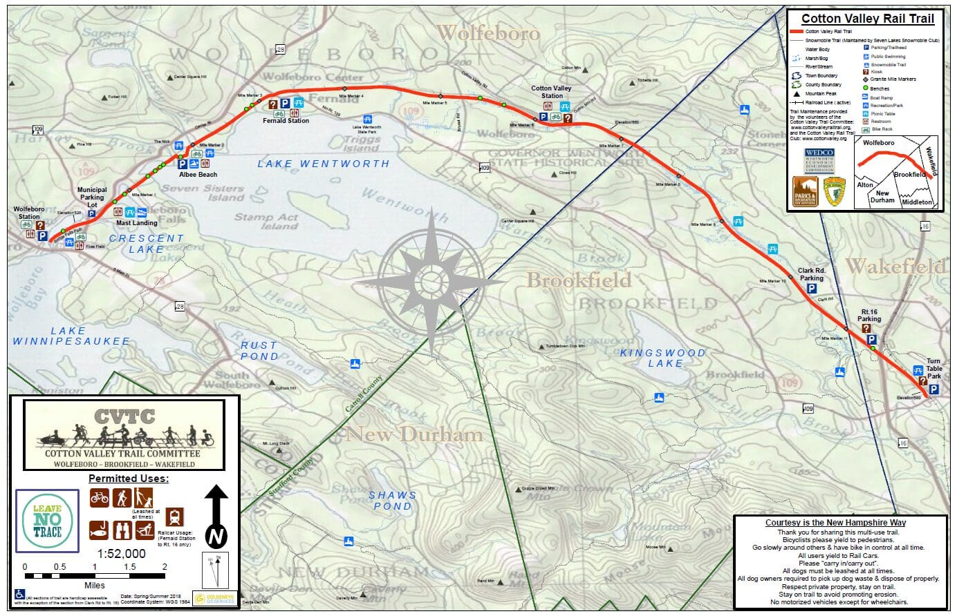
The Cotton Valley Rail Trail is 12 miles long and begins at Depot Street in Wolfeboro and ends at Turntable Park in Wakefield. This trail is a great four-season trail and is not only exceptional for walking and biking, but it is one of only three trails under DNCR management that have rails intact and are used recreationally by local rail car clubs. The trail begins in downtown Wolfeboro, just across the street from Lake Winnipesaukee's Back Bay, and the trail's usable surface ends at Fernald Station, Rt. 109, Wolfeboro, NH. The Cotton Valley Rail Trail has beautiful scenery, especially along the two causeways, Lake Wentworth and Crescent Lake.
The speed limit is 12 MPH! Slow down and enjoy the ride.
Pedestrians, horses, and snowmobiles have the right of way. Be courteous.
Stay on the trail or stay home.
Cotton Valley Rail Trail Map (color)
Cotton Valley Rail Trail Map (grayscale)
Permitted Uses
Hike, Bike, Rail Car, Snowshoe, Nordic, Snowmobile, and Mushing.
Parking Areas
Wolfeboro:
• Old railroad Depot on Depot Street. Take Route 28 to Route 109 (North Main Street) and turn right onto Railroad Ave. Just ahead on Depot Street is the old Wolfeboro Depot.
• Fernald Station off Route Rt. 28/109 North (3.2 miles from Wolfeboro Center ) to the flashing yellow light intersection with Rt. 109 and take a right. Fernald Station will be 1/4 mile on your left.
• Intersection and Cotton Valley Road and Cotton Mountain Road
Brookfield:
• Clark Road
Wakefield:
• Turntable Park
Organizations that work with the Bureau of Trails to help maintain this trail are:
Cotton Valley Trail Committee (CVTC)
Cotton Valley Rail Trail Club (CVRTC)
Wolfeboro Snowmobile Club
Seven Lakes Snowmobile Club
SEABROOK, NH

POINTS OF INTEREST
- Merrimack River Overlook
- Steven's Nature Trail
- Dog Park
- Downtown Amesbury
- Downtown NewburyPort
- Waterfront Boardwalk
Wind: 17mph NW
Humidity: 63%
Pressure: 29.73"Hg
UV index: 0
48°F
50°F
50°F
48°F
52°F / 46°F
52°F / 45°F
57°F / 48°F
57°F / 48°F
COASTAL TRAILS NETWORK RULES
SALISBURY
3.6 miles paved
Connects to Ghost Trail, Clipper City Rail Trail & Seabrook-Salisbury Trail Connector
Please note that a section of Salisbury’s Old Eastern Marsh Trail will be closed from time to time this Winter and Spring because of construction at Partridge Brook Park behind the Salisbury Elementary School. Click here for full details.
•
• • Salisbury Art Stroll on the Old Eastern Marsh Trail
• • • • • • • • 1 / 9
DESCRIPTION
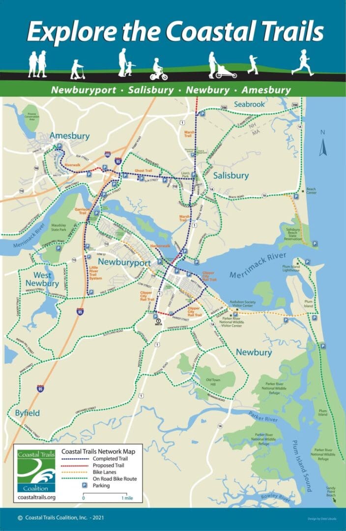
The Old Eastern Marsh Trail offers views of the Merrimack River, a nature trail near the 0.4-mile marker, and a beautiful expanse of the Great Marsh with a tidal river crossing, a wooded boardwalk, a trail bridge over US Route 1, and miles of woodlands. It connects to the Ghost Trail at Lion's Park and to the Clipper City Rail Trail.
Sites and features along the way include:
• Merrimack River overlook
• Steven’s Nature Trail
• Great Marsh with a tidal river crossing
• Nesting turtles in June
• Birdwatching
• Beautiful woodlands
• Fenced dog park
• Salisbury Elementary School
• Interpretive signs
• Partridge Brook Park
The trail is maintained by the Town of Salisbury and Coastal Trails Coalition volunteers.
CONNECTIONS
The Old Eastern Marsh Trail connects to the Clipper City Rail Trail to the south, the Ghost Trail to the west, and the Seabrook-Salisbury Trail Connector to the north.
Eastern Marsh Trail to Clipper City Rail Trail: Exit the south end of the trail at Friedenfels Street and take the Gillis Bridge Connector trail under Route 1. Cross the Gillis bridge via the sidewalk to pick up the Clipper City Rail Trail in Newburyport.
Eastern Marsh Trail to Ghost Trail: The Eastern Marsh Trail connects to the Ghost Trail at Lion's Park. The Ghost Trail heads 2 miles west to Elm St in Amesbury.
Eastern Marsh Trail Seabrook-Salisbury Trail Connector: The northern end of the Eastern Marsh Trail connects to the Seabrook-Salisbury Trail Connector at the MA/NH state line.
FUTURE PLANS
The Old Eastern Marsh Trail is complete. The first portion of the trail, which runs from the Merrimack River to Mudnock Road, was opened in 2010. The extension of the trail to the Massachusetts/New Hampshire line opened in the fall of 2021.
The northern end of Old Eastern Marsh Trail currently ends in Seabrook, NH. Plans are underway for the New Hampshire Seacoast Greenway (NHSG). NHSG is a proposed bicycle and pedestrian route that will connect the eight coastal communities of Seabrook, Hampton Falls, Hampton, North Hampton, Rye, Greenland, New Castle, and Portsmouth. The route will total 17.2 miles, and it is anticipated that virtually all of it will use the abandoned corridor of the former Boston and Maine Railroad from Seabrook to Portsmouth.
In a larger context, the Old Eastern Marsh Trail is a link in the East Coast Greenway, a nearly 3,000-mile network of connected trails from Calais, Maine, to Key West, Florida.
